
Garmin was co-founded in October 1989 by Dr. Min Kao and Gary Burrell. The company is in 35 countries worldwide and has since introduced GPS navigation and wearable technology to the automotive, aviation, marine, and other industries. It first entered the commercial marine industry in 2003 and has since expanded its product lines to include Fusions and Navionics. Garmin Fusion is a marine audio entertainment line designed to withstand the harshest environments. Navionics is a cartography format that provides detailed maps of lakes, rivers, and coastal waters worldwide.
Dr. Kao is credited with the breakthrough design and engineering of GPS software technology that formed the foundation of the original Garmin product line. He is currently the company's executive chairman, providing ongoing support for the company’s strategic planning and business development.
Garmin's nautical charts, integrated with Navionics, offer a straightforward path for commercial fishermen worldwide. Continuously updated by multiple public and private sources, proprietary surveys, official Notices to Mariners, and user-reported updates, these charts are a reliable tool for navigation. They provide detailed information on port plans, safety depth contours, tides, currents, and navigational aids such as channel markers, marine protected areas, hazards, and wrecks. Garmin's GPS systems also make it easy to locate nearby marine services, enhancing the efficiency of your operations.
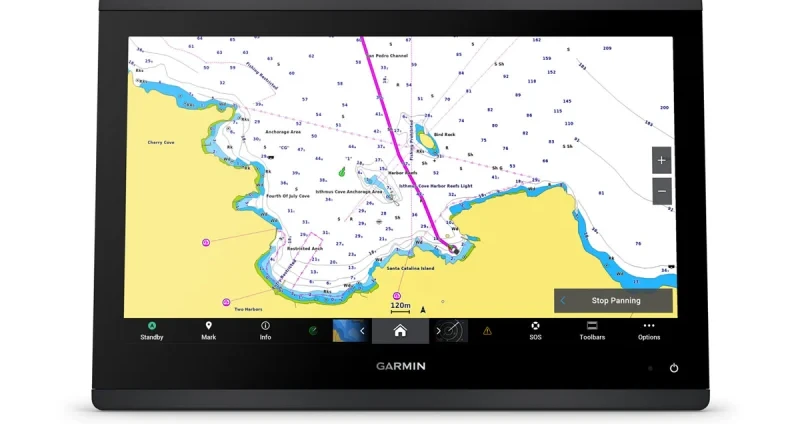
The Garmin GPSMAP 1623 chartplotter, available in 7”, 9”, 12”, and 16” displays, is designed for seamless integration with most engines. Digital switching and OneHelm integrations offer easy connectivity to compatible third-party devices. This versatility and connectivity make it a user-friendly tool for commercial fishermen.
The coastal and inland mapping includes Auto Guidance+ technology and availability for downloadable daily updates. An app called ActiveCaptain can connect your mobile and Garmin device, giving you access to charts and the fishing community. The app on your mobile can set markers and routes and send them directly to your chartplotter.