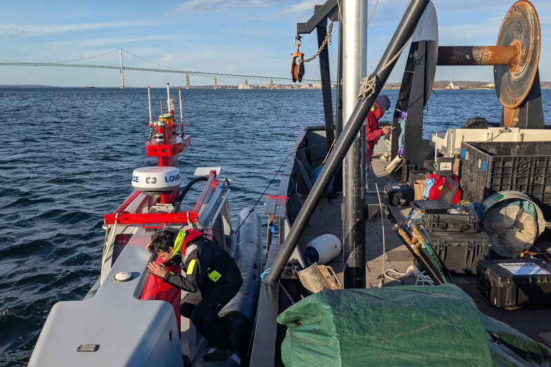
Scientists with the National Oceanic and Atmospheric Administration used its 25-foot DriX autonomous research vehicle for a 20-day spring mission in southern New England waters, collecting data on fish and plankton within five offshore wind energy areas.
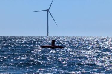
Those wind power projects, like Ørsted’s Revolution Wind 65 turbines south of Rhode Island, are now under severe pressure from the Trump administration’s opposition to all forms of wind and solar generation.
But the amid the turmoil, National Oceanic and Atmospheric Administration researchers are still learning how the new generation of autonomous and semi-autonomous vehicles can fill in the margins of ecosystem and fisheries surveys, in areas where it’s more difficult to operate NOAA’s big science ships.
The April 16-May 5 expedition by ocean researchers with the Northeast Fisheries Science Center was the second DriX survey out of Narragansett Bay, R.I., with the probe operating nearly around the clock for nearly three weeks.
"Uncrewed systems have the ability to support various stock and ecosystem assessments through data acquisition, particularly in areas that have traditionally been or are increasingly becoming challenging to sample,” Conor McManus, the Advanced Technology Program lead for the science center, said in a statement. “We are learning more about how marine ecosystems are changing while improving the technology and operations to be able to use it more expansively in the future."
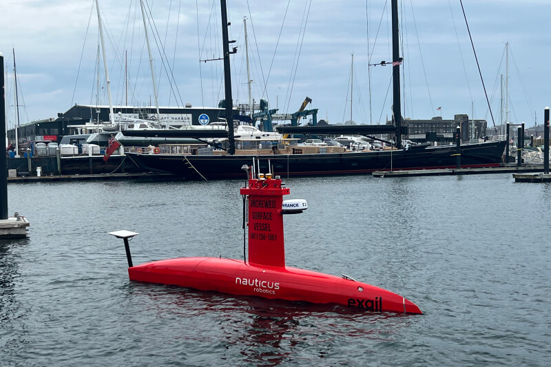
The DriX is programmed to collect data along transect lines, but can correct its course to avoid objects in the water, and remote operators on shore can take control if needed. The DriX can carry an array of sensors to collect oceanographic data. For this survey, DriX was outfitted with:
· Seapix multibeam sonar (150 kHz)
· Konsberg EK80 echosounder (38, 70, 120, 200 kHz)
· Nortek Signature 500 kHz echosounder and acoustic doppler current profiler
According to the science center, “the DriX could help fill data gaps by working in tandem with our long-term ecosystem surveys, such as the Bottom Trawl Survey. The science center’s surveys, including the Bottom Trawl, have been consistently collecting data on fisheries, ocean conditions, and habitat from the Gulf of Maine to North Carolina for more than 50 years.”
During the first week, the DriX was deployed by scientists on board the R/V Gloria Michelle, a 72-foot research vessel homeported in Woods Hole, Mass. They calibrated the acoustic equipment and plankton sampling systems while collecting oceanographic data in the Revolution Wind Energy Area.
The Trump administration issued a stop-work order against Ørsted Aug. 21, seeking to shut down the project with construction now almost complete. Ørsted is certain to challenge the order in court, but it’s another major blow against the company, which saw its stock value plunge 17 percent Monday on the news.
Still NOAA researchers say uncrewed scientific platforms can supplement vessels and aircraft to help address “gaps in long term oceanographic datasets” as “these gaps become a more frequent challenge in an increasingly crowded ocean.”
NOAA and the Bureau of Ocean Energy Management developed a survey mitigation strategy during the Biden administration’s push to develop offshore wind power. The DriX vehicle collected data during the same time period as the Northeast Fisheries Science Center’s annual spring Bottom Trawl Survey, the longest running survey of its kind in the world.
The DriX traveled 1,678 nautical miles and collected data in and around five planned wind energy areas, ranging from the five-turbine Block Island Wind Farm pilot project built in 2016, to Sunrise Wind east of Long Island which has not been built and is on hold amid the regulatory turmoil.
Unlike conventional research vessels, the DriX can sample as close as 65 feet from wind turbines.
“The DriX used acoustic transducers to collect data that will help compare fish and plankton aggregations around different levels of marine development. It will also allow scientists to map the distribution of fish and plankton in and around wind energy areas,” according to NEFSC researchers. “Scientists will use the data to investigate the potential effect of ‘wind wakes,’ or reduced wind energy behind the turbines, which could influence ocean mixing and productivity.”
The DriX collected data while traveling up to 10 knots and was safely worked in 6-foot seas, conditions that would be difficult for a crewed boat of that same size. The Drix was paused for maintenance and refueling every three to four days, while technicians with Exail, a private company that developed the technology, remotely monitored the vehicle from the University of Rhode Island’s Inner Space Center. For safety those technicians piloted the DriX while it maneuvered around wind turbines and other obstacles.
The first DriX survey was conducted during fall 2023, and with new data from the spring 2025 survey scientists plan to study patterns in fish and plankton abundance across seasons and years, as well as patterns across day/night cycles. The DriX also samples throughout the tidal cycle, which is important to study areas that experience large tidal changes, including around Nantucket, Mass.
Scientists need to understand the distribution of plankton and small forage fish to better predict how protected species including whales and sea turtles are using ocean habitats. Of particular concern is the endangered North Atlantic right whale.
To study habitat use, the DriX sampled in prey field areas where right whales have previously been documented foraging. DriX carried high frequency echosounders on this survey that can “see” copepods, the favorite food of right whales.
"Uncrewed systems have the ability to survey important right whale foraging areas during times that are difficult to access with traditional vessels,” said Chris Orphanides, the science center's protected species lead for marine development. “These technologies could provide insights on habitat use and prey distribution that will be beneficial to management, and that otherwise would be difficult to achieve."