Driven by long-term sea level rise and weather trends, high tide flooding events on the East and Gulf of Mexico coasts are now occurring at twice the rate recorded in 2000, according to new findings from the National Oceanic and Atmospheric Administration.
“It’s accelerating in fact along the East and Gulf coasts,” said William Sweet, an oceanographer with NOAA’s National Ocean Service, during on online media presentation by the agency Tuesday.
“The newly released information documents changes in high tide flooding patterns from May 2021 to April 2022 at 97 NOAA tide gauges along the U.S. coast,” according to a narrative issued by NOAA. “It also provides a flooding outlook for these locations through April 2023 and projections for the next several decades.”
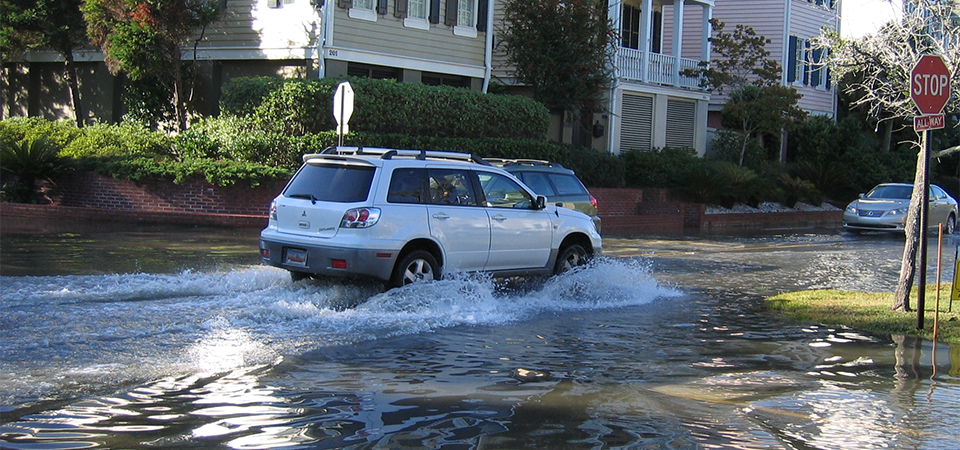
High tide flooding, commonly called nuisance or “sunny day” flooding by forecasters, is on the increase in U.S. coastal communities owing to a past century of sea level rise and now by climate change. NOAA experts define it as happening when tides 1.75 to 2 feet above the daily average high tide. The result is tidal waters spilling onto usually dry streets and bubbling out of storm drains connected to tidal waters.
The trend means that flooding problems that decades ago occurred only during storms now happen more routinely during the full moon phases or times of prolonged currents and onshore winds.
The National Ocean Service reported all-time high tide record days at three U.S. locations between May 2021 and April 2022.
On the Atlantic coast, Reedy Point, Delaware, saw six high tide flooding days in 2022, one more event than 2021. In the Pacific, Kwajalein Island in the Marshall Islands observed four high tide flooding days, which increased by one event from 2021. Also on the Atlantic Coast, the water level station at Springmaid Pier, South Carolina, near Myrtle Beach, S.C., tied its 2021 record with 11 high tide flooding days observed.
NOAA projections predict high tide flood frequency between May 2022 and April 2023 will average 3-7 days, the same as the previous year, but an increase from the 2-6 days expected between 2019 and 2020.
The effects are felt in major cities on the East Coast, where New York City experienced 13 high tide flood days in 2021-22 and can expect nine to 15 days in the coming year, said Sweet. Boston is in line for 11 to 18 flood days, he said.
Historically, the Northeast states were regularly battered by winter gales that discouraged urban over-development in vulnerable zones, Sweet noted. But development pressures are nevertheless pushing into potential problems on previously filled urban land near the waterfronts.
“The tide is sneaky. The tide is going to go where it goes,” said Sweet. Along with sea level rise, navigation channels dredging to accommodate deep-draft shipping may contribute to the volume of water moving during tidal events.
The National Ocean Service data shows some of the biggest risks to New Orleans, La., and Houston, Texas. Sea level rise effects there are compounded because “the land is sinking,” said Sweet.
The southern Louisiana coast and wetlands are starved of sediment that should be supplied by the Mississippi River and can’t replace the elevation lost to soil compaction, at a rate around 1 inch every two and a half years, said Sweet. The Houston region is similarly affected by drilling and withdrawal of oil and groundwater supplies.
On top of long-term sea level rise, high tide days are influenced by periodic meteorological and ocean conditions, and the gravitational pull of the moon. Those lunar cycles are affected by a “wobble” in the moon’s orbit that recurs on an 18- to 19-year pattern, said Sweet.
The wobble “is on the downside now, so that’s helping us a little,” he added.
Conditions over the past year and into 2023 are influenced by the ongoing effects of La Niña: a periodic meteorological event that steers coastal storm tracks and brings cooler than normal Pacific ocean surface temperature and lower than normal sea surface heights off the western U.S. The 2023 outlook predicts high tide flooding frequencies along the West Coast and in Hawaii and the U.S. Pacific Islands will be lower.
By 2050, national scale high tide flooding is expected to occur an average of between 45-70 days per year. Long-term projections are based on the ranges of expected relative sea level rise of about a foot, on average, across the United States by 2050. Data specific to each NOAA tide gauge can be found on The State of High Tide Flooding and Annual Outlook website.
Sweet stressed that the purpose of the report and website resources is not to alarm people, but to equip them to plan for what lies ahead in coastal communities.
“It’s not an exact science. What we are doing is to provide trajectories,” he said. “Use the tide gauge data, and plan accordingly.”