The eight U.S. regional fishery management councils recently issued a report outlining how conservation rules already in effect limit fishing in most federal waters – a new reply to calls for conserving 30 percent of those areas by 2030.
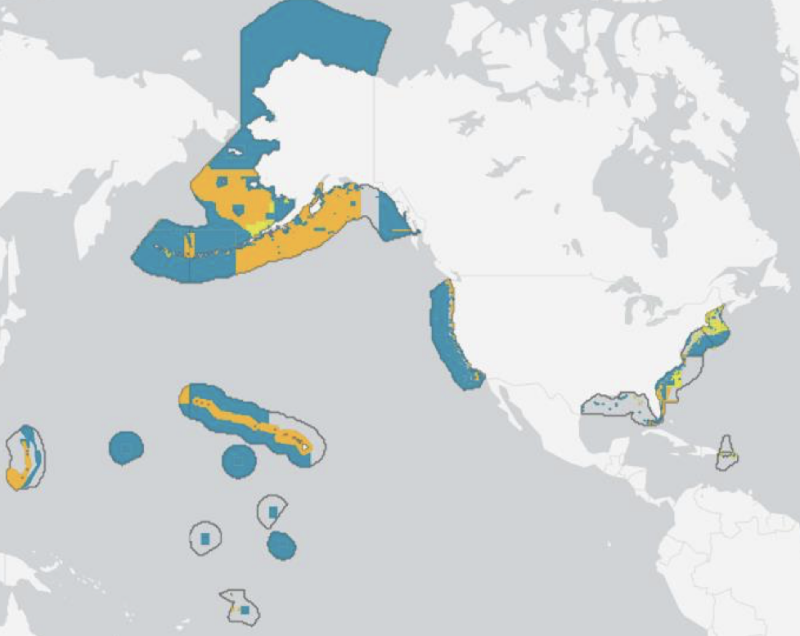
The report, titled An Evaluation of Conservation Areas in the U.S. Exclusive Economic Zone, names 648 conservation areas subjected to fishery management rules covering nearly three-quarters of federal waters.
“These findings demonstrate that a large portion of federal waters are protected from fishing activities that could negatively impact the environment,” according to a joint statement on behalf of the regional councils by the Council Coordinating Committee.
It’s a position paper on the continuing debate over the Biden administration goals for U.S. land and water conservation targets. Often referred to by the shorthand “30x30,” the goal is part of a global effort by environmental and conservation groups.
Since it was introduced early in the administration, the 30x30 concept has brought passionate arguments, with some scientists and fishery managers saying it raises the danger of targeting viable, environmentally responsible fisheries by overstating the case for marine protected areas. The councils’ report is a new marker in that debate.
The Council Coordinating Committee includes the chairmen, vice chairs and executive directors of the councils who meet twice a year. The report was issued following their May meeting in Key West, Fla., and is billed as “a first-ever synthesis of conservation areas in federal waters of the United States.”
The report enumerates 648 conservation areas covering more than 72 percent of federal waters, almost 3.4 million square miles. With the report, the councils are recommending the areas be included in the American Conservation and Stewardship Atlas, being compiled as part of the Biden administration’s America the Beautiful initiative.
"Our subcommittee produced a first-of-its-kind, groundbreaking, and highly detailed analysis of the conservation areas developed by all eight regional fisheries management councils under our authority mandated by the Magnuson-Stevens Act,” said Eric Reid, Chair of the CCC Area-Based Management Subcommittee. “These conservation areas are designed to maintain the productivity and biodiversity of marine ecosystems and balance fishery access to a wide variety of user groups.”
The committee says those areas were analyzed using a new review process, defining each conservation area and screening them “relative to qualifying criteria based on a combination of international standards for conservation and the America the Beautiful principles.”
The resulting report includes an examination of fishing gear restrictions, “with a focus on various configurations of ‘bottom tending’ gear which contact the sea floor. According to the report, bottom trawling is prohibited in over half of U.S. federal waters, and over a third of the U.S. federal waters include prohibitions on all bottom tending gears.”
Appendixes to the report include summaries and maps of each council’s conservation areas. The management subcommittee also developed an online dashboard tool as a companion to the report, and will continue to refine it in the months to come.
“The CCC strongly encourages NOAA and other agencies involved in Atlas development to incorporate the conservation areas identified in the report,” said Dr. Greg Stunz, the committee chair. “By including these areas in the Atlas, the U.S. effectively demonstrates how the Councils’ fishery management measures directly result in improved conservation outcomes that benefit sustainable fisheries, other marine species, and habitats.”