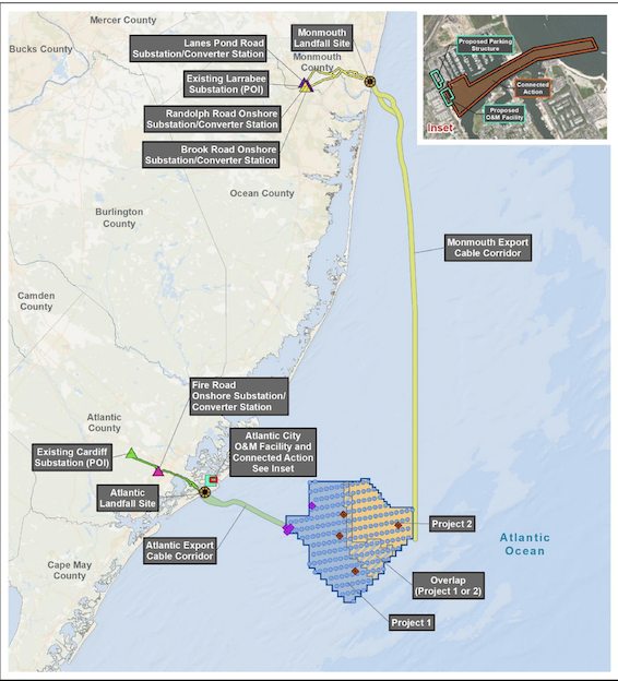
A draft environmental impact statement for the Atlantic Shores wind project off New Jersey includes alternatives that could reduce the number of wind turbines and cables to reduce their visual impact on coastal communities and impact on fish habitat.
The planned 1,510-megawatt Atlantic Shores array off Atlantic City and Long Beach Island, N.J., would at its closest point be 8.7 nautical miles from shore. The potential visual impact of up to 200 turbines with their rotor tips 1,000 feet above the ocean has brought sustained criticism and legal challenges to the Bureau of Ocean Energy Management from coastal homeowners and municipal governments worried about the potential effects of wind projects on tourism.
Fishing interests are concerned about environmental effects of building turbines, and operational and safety difficulties they could present – particularly for scallop and surf clam vessels that historically fish off New Jersey. The BOEM draft document announced Monday includes options for moving some turbine and cable locations to avoid fish habitat, and create a buffer setback between the Atlantic Shores lease and the neighboring Ocean Wind 1 project Atlantic City.
The DEIS document states that the National Marine Fisheries Service “identified two areas of concern (AOCs) within the Lease Area that have pronounced bottom features and produce habitat value. AOC 1 is part of a designated recreational fishing area called ‘Lobster Hole.’ AOC 2 is part of a sand ridge (ridge and trough) complex.”
One alternative for avoiding the Lobster Hole would remove up to 16 wind turbine locations, one offshore substation and their associated cables.
Two alternatives for reducing impacts on sand ridges would remove 6 or 13 turbine locations and their associated cables. A third “micro siting” alternative proposed by Atlantic Shores would shift the location of 29 turbines and a substation beyond a 1,000-foot buffer around the sand ridge areas.
Three alternatives look at reducing visual impacts as seen from shore:
- Excluding 21 turbine positions with 12 miles of shore, and restricting remaining turbines to a maximum hub height of 522 feet above mean sea level and a maximum blade tip height of 932 feet.
- Removing 31 turbine locations within 12.75 miles, with the same height restrictions.
- Cutting 6 turbines positions closest to shore within 10.8 miles, with remaining height restrictions.
Another alternative would establish a setback ranging from 0.81 nautical miles to 1.08 nautical miles between the Atlantic Shores southern area and Ocean Wind 1 to the south, “to reduce impacts on existing ocean uses, such as commercial and recreational fishing and marine (surface and aerial) navigation,” according to the BOEM document. That would involve excluding or relocating 4 to 5 turbine locations.
BOEM is planning two New Jersey public meetings on the DEIS: June 21 at 5 p.m. at the Holiday Inn Manahawkin/Long Beach Island, 151 Route 72 West, Manahawkin; and June 22 at 5 p.m. in the Atlantic City Convention Center, 1 Convention Blvd, Atlantic City.