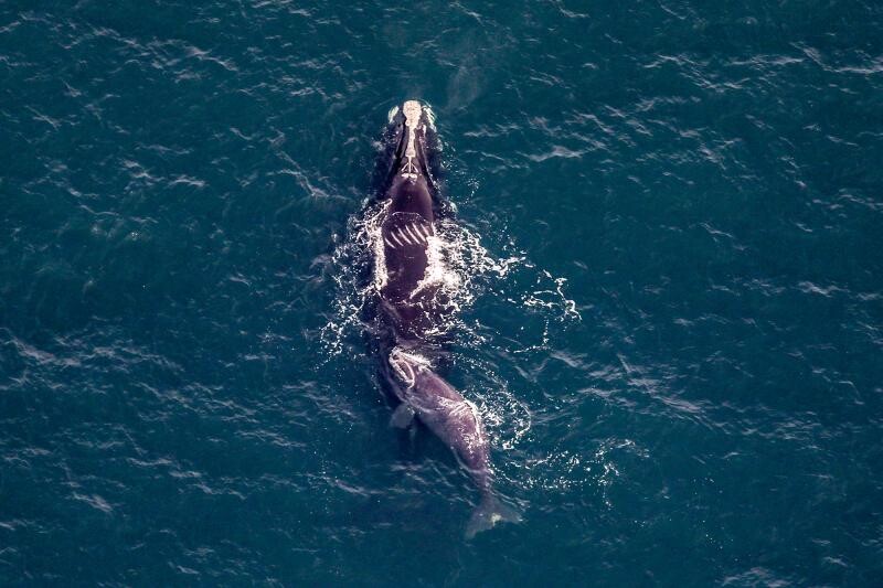
Endangered North Atlantic right whales live in heavily trafficked waters along the U.S. East Coast. Their habitat often overlaps with shipping lanes and port and harbor entrances, which puts them at high risk for vessel strikes—a primary threat to the species. Collisions with large whales can also result in significant and costly damage to boats and injury to passengers. Now, NOAA and partners are using an existing maritime safety technology in a new way to reduce the risk of vessel strikes.
The Automatic Identification System (AIS) transmits the location, speed, and other characteristics of vessels in real time for navigation safety purposes. All commercial vessels 65 feet or longer are required to carry AIS devices onboard. Together with our partners, we are building a speed limit alert network powered by AIS technology that delivers timely text messages to vessels traveling within important right whale habitats.
Most vessels 65 feet or longer are required by federal law to travel at 10 knots or less in designated locations—called Seasonal Management Areas—at certain times of the year. With this real-time messaging network, shore-based AIS transceiver stations can detect vessel speeds within Seasonal Management Areas. If a regulated vessel is traveling faster than 10 knots, it will receive an alert.
Like radar speed signs for drivers, these messages are designed to increase awareness of speed limits and remind mariners to slow down in areas where right whales are likely to be present. Transiting at 10 knots or less allows mariners to keep a close eye out for right whales and other protected species, and reduces the chances of collisions being fatal.
This outreach tool is part of our broader efforts to use transformational technologies to address threats to the North Atlantic right whale.
"This technology allows us to reach mariners where they are," said Caroline Good, fishery biologist at NOAA Fisheries. "It advances our goal to promote a sustainable coexistence between thriving marine industries and endangered North Atlantic right whales."
The AIS speed limit alert network is the result of a new and growing public-private partnership. MotionInfo, a maritime data company based in Massachusetts, leads the installation and maintenance of the alert network’s shore-based AIS transceivers, known as “StationKeepers.” These transceivers communicate with vessels’ AIS devices and broadcast the text messages.
NOAA and MotionInfo led a pilot project in the Cape Cod Bay Seasonal Management Area during winter 2024. They used a newly installed StationKeeper at the Stellwagen Bank National Marine Sanctuary’s office in Scituate, Massachusetts.
The network sent messages to several commercial cargo and tanker vessels’ AIS receivers, notifying them that they exceeded the speed limit. The receivers replied with acknowledgement messages, verifying that the speed alerts were delivered successfully to the vessel’s AIS unit. The vessels received additional alerts until they slowed to the speed limit or exited the area.
This real-time feedback helped mariners take immediate action. During the pilot period, 83 percent of vessels slowed down after receiving an AIS message, improving compliance.
"It’s exciting to develop a technique that increases vessel compliance with speed limits, which directly and positively impacts right whale survival," said David Wiley, research ecologist for the sanctuary.
Many state and local agencies, nongovernmental organizations like the International Fund for Animal Welfare, science centers, and other stakeholders have since joined this partner-driven effort. Our partners are committing critical funds to implement the new system, providing sites to host the AIS transceiver stations, and raising awareness within coastal communities.
Expanding Along the Atlantic Seaboard
The alert network’s reach is expanding coastwide. So far, MotionInfo has installed over 60 StationKeepers. The U.S. Coast Guard and the Federal Communications Commission issue permits and licenses for each StationKeeper.
MotionInfo coordinates with local and state agencies and nonprofit organizations to identify viable locations to install StationKeepers. Host locations for StationKeepers must have sufficient height, proximity to the coast, power, and—ideally—an internet connection.
“We’ve had great success working with folks to find locations. When they hear about the project, they want to be involved and help out,” said Moses Calouro, CEO of MotionInfo.
Additional Uses for AIS Technology
The interest in using AIS technology extends to efforts beyond the North Atlantic right whale. NOAA is testing out similar technology to notify vessels of voluntary speed reduction areas to protect endangered blue, fin, and humpback whales off California. The U.S. Coast Guard and Ocean Wise are also working to add AIS capability to their existing cell-based Whale Report Alert System in the Puget Sound region. The Marine Exchange of Alaska, a maritime communication and regulatory compliance organization, already uses AIS to send weather and other safety information to mariners.
Marine electronics manufacturers are also assisting with this effort, helping ensure that chart plotter and navigational system software seamlessly detect and display these messages to mariners. Garmin, a global marine electronics manufacturer, recently released a software update for its customers that includes full support for the new AIS alerts, displaying them as a pop-up on their navigational system screens.