Escalating debates over siting offshore wind energy projects has made stakeholders reliant on Coast Guard vessel traffic data to scope out potential conflicts. The National Oceanic and Atmospheric Administration has been making improvements and new online tools to open that knowledge to a wider public.
The Automatic Identification System that tracks vessel movements with transponders on ships has helped create an “AIS database of 30 billion-plus vessel locations has become the go-to resource for maritime planners and ocean geospatial tech experts,” according to a recent summary from NOAA.
That data is a base for a NOAA website, MarineCadastre.gov . Cadastre is the ancient system of metes-and-bounds surveying of real estate on land.
For the ocean, NOAA developed the tool AccessAIS to help users access AIS data and more from MarineCadastre.gov on birds, economics, boundaries, federal regulations and other factors in planning.
“Because of AccessAIS, what used to take hours or days of data downloading and processing can now be ordered and delivered in minutes,” says Dave Stein, a geographer at NOAA’s Office for Coastal Management and a member of the tool team. “All users need to do to gain access to this huge information resource is to draw a box around their geographic area of interest and select a time range from 2017 to 2022.”
New AIS data are added regularly, and tool uses are growing each month.
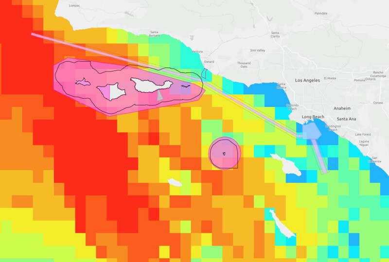
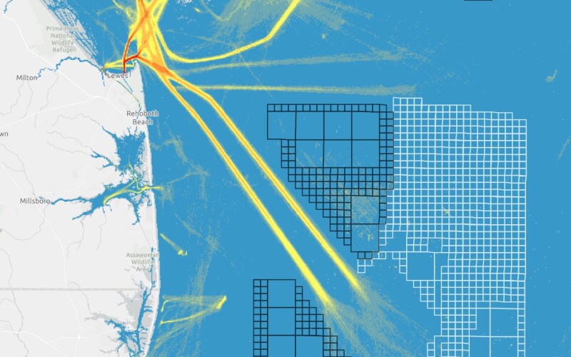
The Coast Guard and its partners in the Atlantic Coast Port Access Route Study used the database to ensure that emerging energy plans did not conflict with the ship traffic and navigational safety of port users.
Commercial fishing vessel owners in southeastern New England used AccessAIS to document their trawl widths, paths, and turns. Fishermen and industry advocates have used that information to show the Bureau of Ocean Energy Management, NOAA and wind developers potential conflicts with wind turbine placement.
On the West Coast, partners including California’s Port of Los Angeles and NOAA’s Office of National Marine Sanctuaries used AccessAIS data to visualize shipping lane changes that could reduce whale fatalities from ship strikes. In the Northeast, the Stellwagen Bank National Marine Sanctuary in Massachusetts researched how noise from large commercial vessels could negatively affect marine mammals.
NOAA’s National Centers for Coastal Ocean Science used AccessAIS to analyze potential benefits and costs of commercial mussel aquaculture in Northeast coastal waters. At the level of state government environmental agencies, coastal zone managers are using AccessAIS in many states use AccessAIS to develop plans for protecting ecosystems and local economies that depend on those resources.
Maritime industries can use the data to assess risk to their daily operations. Cruise ship operators utilize AIS databases, overlaid with historical hurricane paths, to plan for tropical storms.
In one case of a commercial vessel “hit and run” damaging a bridge, investigators used the AIS tool’s historical data to filter a subset of potential vessels, which helped identify the offending vessel.
Other users have analyzed the risks of buried submarine cables to fishing and trawling vessels. U.S. researchers used the data to model the potential destructiveness of a vessel collision with an offshore liquefied natural gas port facility.
More on the AccessAIS tool can be found here.