I remember reading a story from one of National Fisherman’s back issues that profiled U.K. fishermen who targeted wrecks in the English Channel. The fishermen liked to be on top of the wrecks because they could catch fish created by the structures’ artificial reefs. But they had to be careful of damage to fishing gear. Wrecks can also be a sure sign of dangerous waters.
Whatever your feelings about fishing shipwrecks, it’s probably good to know where they are. That may be easier to do: NOAA Coast Survey announced today that it has improved its online Wrecks and Obstructions Database.
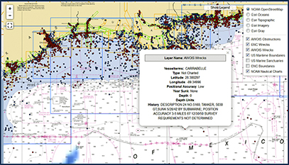
 NOAA Coast Survey has improved its online database of seafloor obstructions, including shipwrecks. NOAA photo. The improved database combines the historic information from Coast Survey’s Automated Wreck and Obstruction Information System with the more authoritative information from its electronic navigational charts. In all, the improved database contains information on 13,000 wrecks and 6,000 obstructions.
NOAA has also expanded the formats that can be used to view the data. For example, you can view original AWOIS and ENC data together in layers and on different map backgrounds. You can also use the data with Google Maps and Google Earth.
Seeing all those red dots on the map is a reminder of the ocean’s deadly toll. Sometimes it’s difficult for me to look at photos of ships underwater. I feel like I’m looking at someone’s grave. It’s unsettling and sad.
But I also understand the value of underwater exploration. Every wreck tells a story, like the torpedoing of the Robert E. Lee. In 1942 a German U-boat hit the passenger steamer while it was traveling from New Orleans to Trinidad. After the attack, the Lee’s escort vessel, the PC-566, dropped several depth charges. The submarine sank with all hands. It is the only known U-boat to be sunk in the Gulf of Mexico.
Both wrecks were recently visited by the E/V Nautilus (though the U-boat is considered a war memorial and can’t be disturbed), which is currently exploring the seafloor of the Gulf of Mexico. You can watch the expedition in real time on a live cam.
The expedition also plans to explore the final resting places of Gulf Penn and Gulf Oil, two oil tankers also sunk by German U-boats. These are particularly important to the researchers because they have a high abundance of large corals growing on them.
I can imagine that for fishermen, who have to understand what’s going on below, it must also be fascinating for you to watch as new life blossoms beneath the waves.
 Want more
news and editorial
delivered to your inbox?
Subscribe to our
free e-newsletter.